
Professionals in 2025 use top models like the DJI Mavic 3T, Autel EVO Max 4T, and DJI M30T. These drones give accurate results in tough places. The global thermal imaging drone market is growing fast. It will reach $7.92 billion in 2025.
Metric/Aspect | Details |
|---|---|
Market Size 2025 | $7.92 billion |
Key Applications | Inspection, search and rescue, security, firefighting, agriculture |
Drones help teams find people fast. They spot problems and collect important data. This makes drones very important for today’s work.
Key Takeaways
The best thermal imaging drones in 2025 can spot heat clearly. They fly for a long time and have good safety tools for hard work. Drones like DJI Mavic 3T, Autel EVO Max 4T, and DJI M30T are great for search and rescue. They also help with inspections and public safety jobs. These drones have high-resolution thermal cameras and dual sensors. This helps teams find problems quickly, even at night or in bad weather. Picking the right drone means looking at flight time and camera quality. You should also check how easy it is to control and what special features it has for your job. Keeping drone data safe is very important. Many drones use encryption and follow strict rules to protect private information.
Top Thermal Imaging Drones
Leading Models for 2025
Experts say some drones are the best for thermal imaging in 2025. These drones have strong sensors and tough bodies. They are ready for many jobs. The table below shows the top choices:
Drone Model | Key Thermal Features | Notable Capabilities | Primary Applications |
|---|---|---|---|
DJI Matrice 30T | Dual thermal sensors, AI subject tracking | Zoom lens, laser rangefinder, dual controllers | Search & rescue, security monitoring |
DJI Matrice 350 RTK | Supports Zenmuse H20T thermal camera | Triple gimbal, dual battery, IP54 controller | Industrial inspections, complex operations |
DJI Mavic 3T | Thermal imaging, 20 MP Hasselblad camera | 15 km range, compact design | Search & rescue, firefighting |
Autel EVO Max 4T | Enterprise-grade thermal imaging | Smart controllers, 50 MP JPEGs | Commercial, law enforcement |
Other top drones are the Anzu Raptor Thermal, Autel EVO II Dual 640T V3, and Parrot Anafi USA. These drones have clear thermal sensors and batteries that last a long time. They also keep data safe. Many people use the DJI Mavic 3 Multispectral for special imaging work.
Why These Drones Lead
The best thermal imaging drones have great sensors and fly well. They also have safety features. People pick these drones for many reasons:
High thermal resolution sensors show heat clearly. This helps teams find problems fast.
Long flight times, from 38 to 50 minutes, help with long jobs.
Dual thermal and visual cameras give lots of details for checks and emergencies.
Features like obstacle avoidance and RTK GPS make flying safer and easier.
Strong bodies and weather resistance let drones fly in rain, dust, or tough weather.
Note: Drones like the DJI Mavic 3T and Autel EVO Max 4T have smart features. They use AI to track things and collect data by themselves. These features help with search and rescue, firefighting, and checking buildings.
Makers also care about following rules and keeping data safe. Drones like the Anzu Raptor Thermal and Teledyne FLIR SIRAS meet strict rules for important jobs. The DJI Mavic 3 Multispectral can also help with farming and checking the environment.
Key Features to Compare
Camera and Sensor Specs
People who use thermal imaging drones need clear pictures. High-resolution cameras help them get the right results. The most important things to look at are thermal resolution, thermal sensitivity, and radiometric capability. Drones with a thermal resolution of 1280×1024 make sharper images. This helps teams see small changes in temperature. If a drone has a lower NETD value, it can spot tiny heat changes better. Radiometric sensors record the temperature for every pixel. This helps teams check things closely during inspections.
Other important things are field of view, spectral range, and frame rate. A wide field of view lets the drone see more at once. A high frame rate makes videos look smooth, even when things move fast. Many drones let you change lenses and have image stabilization. They also come with smart software tools. These features, plus strong payload integration, help users pick the right tools for each job. Payloads like dual thermal and visual cameras make the drone useful for many tasks.
Note: Drones with strong thermal features and good payload support can handle hard jobs in big industries.
Flight Time and Range
How long and how far a drone can fly is very important. Longer flight times mean the drone can cover more ground without stopping to change batteries. The table below shows how top models compare:
Drone Model | Flight Time (minutes) | Operational Range (km) |
|---|---|---|
DJI Matrice 4T | 50 | 15 |
DJI Mavic 3T | 45 | N/A |
DJI M30T | 41 | 15 |
Parrot Anafi USA | 32 | 4 |
Skydio 2+ | 27 | 3.5 |
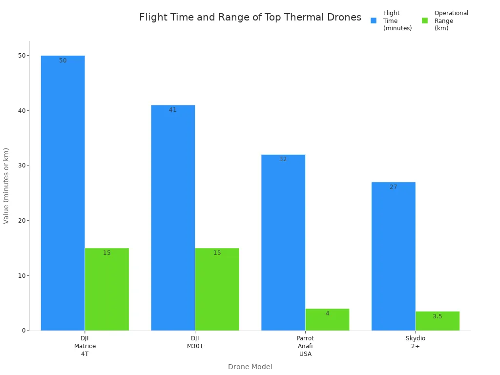
Drones that can carry heavy payloads still work well. This is important for jobs that need special sensors or long flights.
Reliability and Integration
People who work in tough places want drones that fly steady and avoid obstacles. These features keep the drone safe when flying is hard. Good drones use both thermal and visual cameras. This gives teams lots of data for checking things and tracking in real time. Software that works with the drone helps teams look at the data later.
A flexible payload system lets users switch out cameras or sensors. Strong build quality, weather resistance, and easy carrying make drones more reliable outside. When drones work with smart software and data links, they can send and study data right away. This helps teams make quick choices when it matters most.
Tip: Picking a drone with payload options and strong integration helps it stay useful as needs change.
Thermal Imaging Drone Model Comparison
DJI Mavic 3T
The DJI Mavic 3T is a small drone for thermal imaging. It has a 640×512 pixel thermal camera that works at 30 frames per second. It can measure temperatures from -20° to 150°C in high gain mode. In low gain mode, it measures from 0° to 500°C. The temperature readings are accurate within ±2°C or ±2%, whichever is bigger. Its NETD is ≤50 mK, so it can see tiny temperature changes.
Specification Category | Details |
|---|---|
Thermal Camera Resolution | 640×512 pixels @ 30fps |
Temperature Measurement Range | -20° to 150° C (High Gain), 0° to 500° C (Low Gain) |
Temperature Accuracy | ±2° C or ±2% |
NETD | ≤50 mK @ F1.0 |
Digital Zoom | 28x continuous zoom |
Flight Time | Up to 45 minutes |
Max Transmission Distance | Up to 15 km (FCC) |
Sensing System | Omnidirectional binocular vision + infrared sensor |
This drone uses two cameras. One is a 48MP wide-angle camera. The other is a 12MP telephoto lens. Together, they let you zoom in up to 56x. The drone can sense obstacles all around it. It uses the DJI O3 Enterprise Transmission system for safe flights. You can check temperatures and mark problems using the drone’s tools.
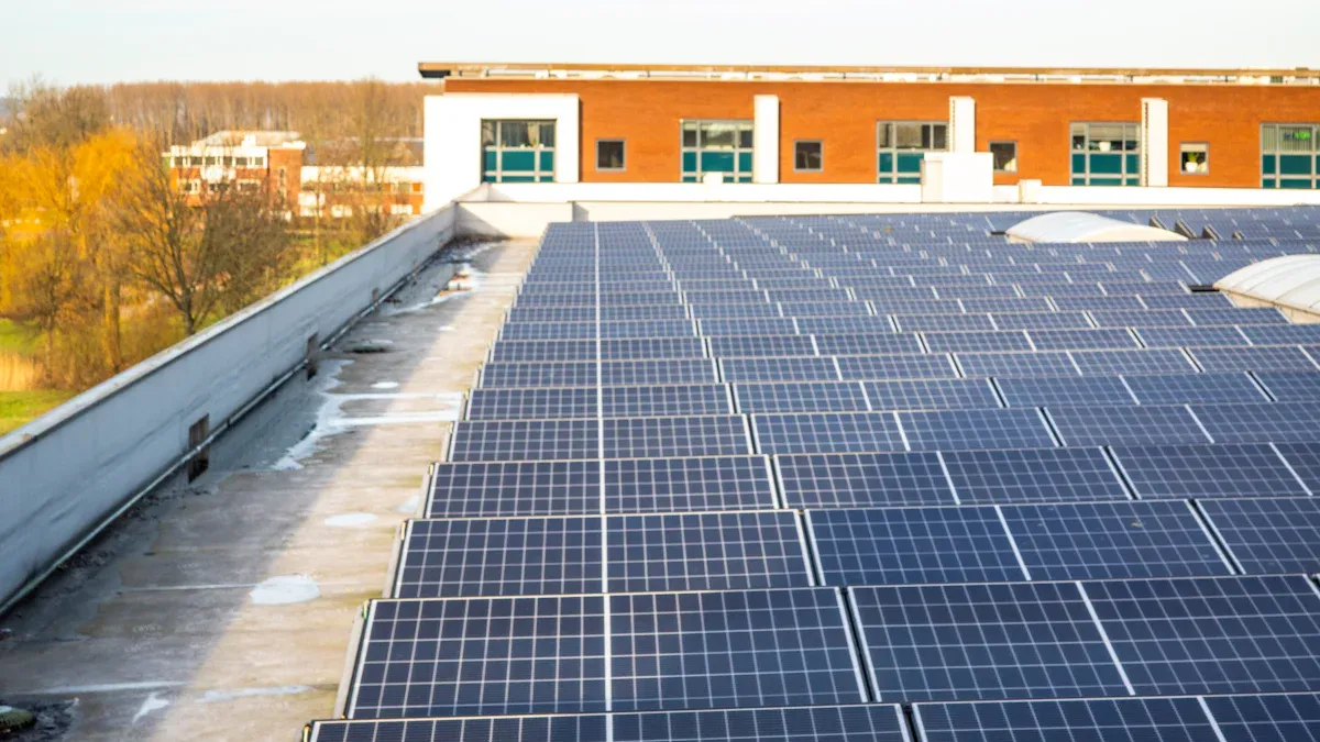
The DJI Mavic 3T is great for checking solar panels, public safety, and watching buildings. It can make inspections much faster, sometimes by more than 80%.
But, the drone has an electronic shutter. This can cause rolling shutter distortion when mapping. The RTK module, which helps with better positioning, is sold separately. The Mavic 3T does not have Time Sync, so it is not as good for very exact mapping as the DJI Mavic 3E. Even with these issues, the DJI Mavic 3T is still a top pick for hybrid inspections and thermal imaging.
Autel EVO Max 4T
The Autel EVO Max 4T has a payload system for hard jobs. Its thermal camera has 640×512 resolution and 16x digital zoom. This helps find heat in smoke or fire. It also has an 8K zoom camera with 10x optical zoom and up to 160x hybrid zoom. There is a wide camera with 4K video for low-light use.
The laser rangefinder can measure things up to 0.75 miles away.
It has smart features like 3D flight path planning and GPS-denied navigation.
AI helps the drone find and follow people or cars.
Millimeter wave radar and binocular vision sensors help avoid obstacles. They can spot things as small as 0.5 inches.
Mesh networking lets many drones work together, even without LTE.
The Autel EVO Max 4T works well for public safety, disaster response, and inspections. It can fly where there is no GPS and can handle wind up to 27 mph. It also works in tough places like smoky areas. The XE version is even better in bad weather and has stronger networking.
The Autel EVO Max 4T is a strong choice for search and rescue, firefighting, and inspections because of its flexible payload and safety features.
DJI M30T
The DJI Matrice 30T, or DJI M30T, is a tough drone for hard jobs. It has a 48MP zoom camera with 5x-16x optical zoom and 200x digital zoom. It also has a 12MP wide camera and a 640×512 radiometric thermal camera. The payload has a laser rangefinder that works up to 1200 meters.
Feature Category | Details |
|---|---|
Camera Capabilities | 48MP zoom (5x-16x optical, 200x digital), 12MP wide, 640×512 thermal (30fps, ±2°C) |
Laser Rangefinder | 3 m to 1200 m, ±(0.2m + D×0.15%) |
Flight Performance | 41 min flight, 51 mph max speed, 33.5 mph wind resistance |
Safety and Redundancy | Six-way obstacle avoidance, dual IMU/barometer/RTK/compass, emergency landing |
Environmental Adaptability | IP55 rating, -20 to 50°C operating temp |
Transmission System | OcuSync 3 Enterprise, four antennas, LTE backup |
Design and Portability | Foldable, 3.77 kg, fits in backpack |
Deployment Features | Quick-lock arms, integrated payload, no pre-flight calibration |
Software and Compatibility | DJI Dock, DJI FlightHub 2, advanced mission management |
Additional Features | Night-optimized FPV, 7-inch RC Plus controller, hot-swappable batteries |
The DJI Matrice 30T has hot-swappable batteries for almost nonstop flying. Its IP55 rating means it can handle dust and water. The drone has six-way obstacle avoidance and backup systems for safety. You can set it up fast, with no need for landing gear or calibration.
The DJI Matrice 30T is a good value for groups that need a reliable drone, strong payloads, and nonstop work in tough places.
The DJI Matrice 30T is heavier and bigger than smaller drones. But it is best for big jobs. It works with many accessories and the DJI Dock for automatic flights. Its built-in payload and smart software make it a top pick for inspections, public safety, and long-term monitoring.
Parrot Anafi USA Thermal
The Parrot Anafi USA Thermal is easy to carry, safe, and has strong cameras. It has a 32x zoom optical camera and a FLIR Boson thermal sensor with 320×256 resolution. The drone records 4K HDR video and has two 21MP visual cameras for clear pictures from far away.
The drone weighs about 500 grams and folds up for travel. It has an IP53 rating for water and dust.
It can fly for up to 32 minutes. The kit comes with extra batteries for longer use.
You can get the drone flying in less than 55 seconds.
It can fly indoors without GPS, which is useful in some places.
The drone is quiet, so it can be used for secret missions.
Data is kept safe with AES-XTS encrypted SD cards. No data is sent to Parrot servers.
The drone is NDAA-compliant, on the Blue UAS Cleared List, and made in the USA.
Feature | Parrot Anafi USA Thermal Details |
|---|---|
Thermal Camera | FLIR Boson, 320×256 resolution |
Visual Cameras | Dual 21MP, 32x digital zoom |
Flight Time | Up to 32 minutes |
Weatherproof Rating | IP53 |
Security | AES-XTS encryption, Blue UAS listed |
Deployment | <55 seconds from case to flight |
The Parrot Anafi USA Thermal’s thermal camera is better than many mid-range drones. It has good zoom and camera options. It does not fly as long or carry as much as the DJI Matrice 350 RTK or DJI Matrice 30T. But it is a good mix of strong thermal imaging, easy carrying, and price. This makes it a good pick for U.S. public safety and inspection teams.
Teledyne FLIR SIRAS
The Teledyne FLIR SIRAS is made for inspections, firefighting, police, and rescue. It has two cameras: one for thermal and one for visible light. It uses MSX technology to mix both images for more detail. The FLIR Boson thermal sensor has 640×512 resolution and 5x digital zoom for exact temperature checks.
Category | Specification Details |
|---|---|
Aircraft Performance | 1 min takeoff readiness, no geofencing, return to home, ±1.5m horiz, ±0.5m vert hover accuracy, IP54 rating |
Imaging & Optical | EO: 16MP (20MP mapping), 2MP at 32x zoom, IR: 640×512 radiometric, 20x digital zoom, FLIR MSX |
Controller & Transmission | Dual band 2.4/5.8 GHz, 9 km range, 720p video, 1000 lumens display, 90 min battery |
Battery & Accessories | Hot-swappable, 31 min flight, local SD storage, compatible with FLIR Thermal Studio |
The SIRAS drone is ready to fly in under a minute. It does not use geofencing, so it can fly anywhere. Hot-swappable batteries help it fly longer. All data is saved on SD cards, not in the cloud. The drone has radar and sensors to avoid crashes.
The SIRAS drone is used for checking power lines and buildings where data safety matters.
Police use it for watching over sensitive places.
The Vue TV128+ payload helps first responders and inspectors with its high thermal sensitivity and clear camera.
The Teledyne FLIR SIRAS is trusted for keeping data safe, being flexible, and having strong cameras. It is a good tool for people who need advanced thermal and visual imaging.
Comparison Table
Specs and Features Overview
People compare thermal imaging drones by looking at things like camera quality, how long they fly, how much they weigh, and what special things they can do. The table below shows how the top drones for 2025 are different:
Drone Model | Thermal Sensor Resolution | Visual Camera Specs | Flight Time (min) | Weight (kg) | Range (km) | Notable Features | Typical Use Cases |
|---|---|---|---|---|---|---|---|
DJI Mavic 3T | 640 x 512 px radiometric | 48MP wide + 12MP hybrid zoom (56x) | Up to 45 | 0.92 | 15 | Obstacle avoidance, real-time analytics | Fire, inspection, law enforcement |
Autel EVO Max 4T | FLIR Boson 640 x 512 px | 4000 x 3000 px | 42 | 1.62 | 20 | Anti-jamming, omnidirectional sensors | Engineering, telecom, tactical |
Parrot Anafi USA | FLIR Boson 320 x 256 px | Dual 21MP with 32x zoom | 32 | 0.499 | 4 | NDAA-compliant, AES encryption | Surveillance, tactical ops |
DJI Matrice 30T | 640 x 512 px radiometric | Zoom (200x hybrid), laser rangefinder | 41 | 3.7 | N/A | IP55 rating, all-weather | Emergency, disaster recovery |
Teledyne FLIR SIRAS | FLIR 640 x 512 px | 16MP stabilized | 31 | 1.5 | N/A | Pure thermal accuracy, no cloud streaming | Grid, HVAC, home inspection |
Yuneec H520E-RTK | FLIR 640 x 512 px | Sony 20MP | 30 | 1.8 | N/A | Hot-swappable payloads, RTK precision | Agriculture, utility inspection |
Walkera Voyager 5T | 640 x 512 px | 30x optical zoom | 38 | 3.2 | N/A | Rugged build, ergonomic controller | Factories, plant inspection |
Tip: Drones with better thermal sensors and longer flying time help teams see more places and find small heat changes fast.
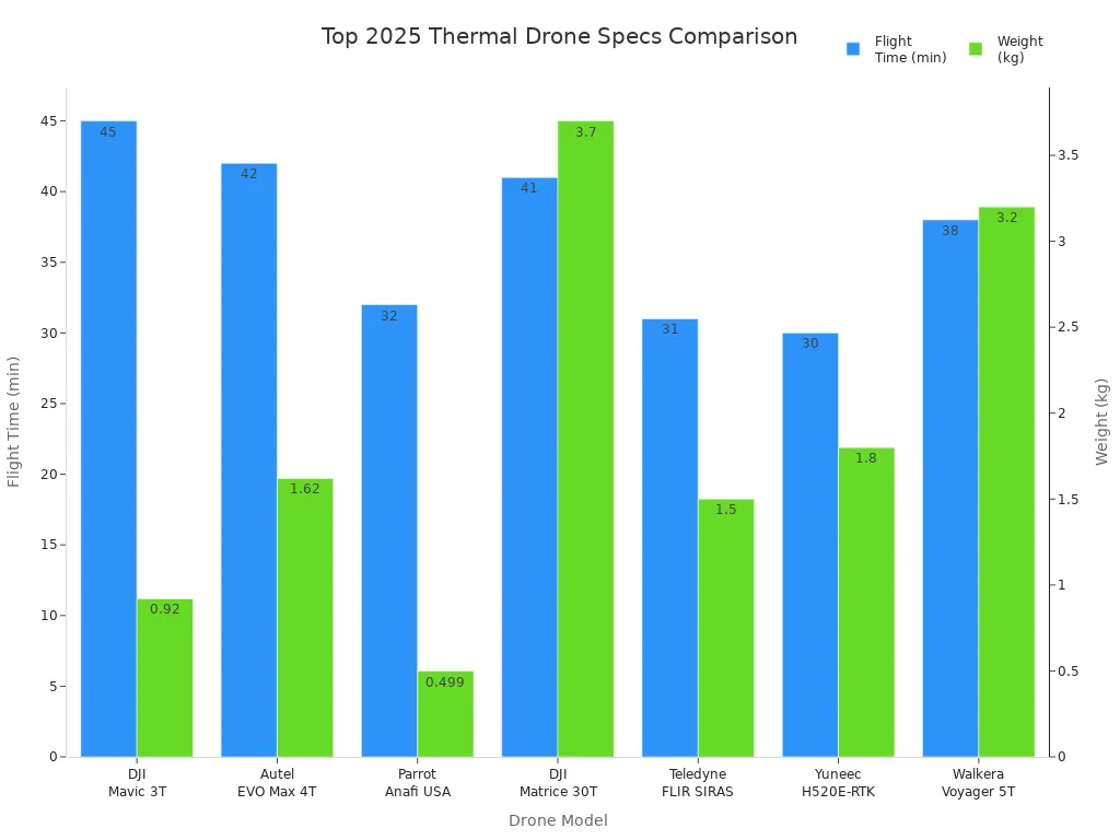
The DJI Mavic 3T is good because it has clear cameras, flies a long time, and has safety tools. The Autel EVO Max 4T can fly farther and has tech that stops jamming, so it is great for tough jobs. Parrot Anafi USA is light and keeps data safe, which is good for government work. DJI Matrice 30T is strong and can fly in bad weather, so it helps in emergencies. Each drone is best for different jobs, like checking buildings or keeping people safe.
Picking the best drone depends on what you need to do. Teams should check the camera, how long it flies, and special features to choose the right one.
Best Use Cases
Search and Rescue
Thermal imaging drones have changed how teams find people. Now, teams use drones with special cameras to see body heat. These cameras work even in smoke, rubble, or at night. Drones can fly for a long time and go far. They are quick to set up, which helps in emergencies. The Parrot ANAFI USA can start flying in less than a minute. It works in bad weather. Its two cameras and GPS help find people fast, even in the dark or far away.
Feature | Description |
|---|---|
Thermal Imaging | Finds body heat in smoke, rubble, or darkness |
Flight Time | 31-55 minutes for longer searches |
Transmission Range | Up to 15 km to cover big areas |
Payload Capacity | Can carry two sensors for more data |
Durability | IP43-IP55 ratings for tough places |
Hot-Swappable Batteries | Change batteries fast during missions |
Obstacle Avoidance | Helps the drone fly safely in tricky spots |
Real-Time Data Transmission | Shows live video and heat images for quick choices |
Quick Deployment | Small and easy to launch |
GPS Integration | Helps find people exactly where they are |
Drones like the DJI M30T and DJI Mavic 3 Enterprise are used a lot for these jobs. Live video and obstacle sensors keep rescuers and victims safer.
Industrial Inspections
Thermal imaging drones are important for checking factories and buildings. They use special cameras to see heat and spot temperature changes, even when it is dark. New drones have both thermal and regular cameras. This lets teams get lots of information in one flight. Features like custom heat maps and live temperature checks help find problems fast.
Feature | Description |
|---|---|
Thermal Camera Resolution | High resolution (like 640×512) for clear pictures |
Radiometric Capabilities | Measures temperature for every pixel |
Flight Time & Range | Long battery life and batteries you can swap |
Stabilization & Overlay | 3-axis gimbals and two cameras for steady, matched images |
Software Compatibility | Works with programs like FLIR Tools and Pix4D |
Environmental Resistance | Built to handle bad weather |
Big companies like DJI, Parrot, and Teledyne FLIR lead in this area. Their drones help check power lines, solar panels, and large areas.
Public Safety
Police and firefighters use thermal imaging drones for many jobs. These drones have strong thermal sensors, zoom, and can fly for a long time. They are tough and send data back safely, even in bad weather. Drones like the DJI Matrice 30T and Autel EVO Max 4T can start fast, fly at night, and help find people better.
Drones help keep responders safe by letting them see danger from far away. They also follow rules and keep data safe, so they are good for police and rescue teams.
Drone Model | Key Features | Flight Time | Public Safety Applications |
|---|---|---|---|
DJI Matrice 30T | 640×512 thermal, 48MP camera, 56× zoom | Search & rescue, firefighting | |
Autel EVO Max 4T | 640×512 thermal, 8K visual, laser rangefinder | 42 min | Law enforcement, inspections |
Parrot Anafi USA | FLIR Boson, 32× zoom, encrypted data | 32 min | Border patrol, tactical ops |
Best Value
The best value drone is the one that fits the job and budget. If you want to save money, the Autel EVO Lite 640T Enterprise is a good pick. It has a 640×512 thermal camera, flies for 40 minutes, and costs less than top models. The Parrot ANAFI Thermal is cheaper and easy to carry, but its camera is not as sharp.
Drone Model | Thermal Resolution | Flight Time | Price (USD) | Best For |
|---|---|---|---|---|
Autel EVO Lite 640T Enterprise | 640×512 | 40 min | $3,359 | High resolution, long flight, best value |
Parrot ANAFI Thermal | 160×120 | 26 min | $1,999 | Entry-level, affordable inspections |
Drones with good cameras, long flights, and safe data are best for checking, watching, and keeping people safe.
Picking the best thermal imaging drone depends on what you need to do. The DJI Mavic 3T is great for checking things. The Autel EVO Max 4T is best for police and rescue jobs. The DJI M30T works well in emergencies. Teams should pick a drone that fits their job and how much they can spend.
Before you buy, look at the comparison table and think about these things:
Decide what you will use the drone for.
Make sure it can fly long enough and the battery lasts.
Check if the camera and sensors are good.
See if the drone is steady and easy to control.
Find out if it can fly by itself.
Read new user reviews to help you choose the best drone.
FAQ
What industries use thermal imaging drones the most?
Lots of jobs use thermal imaging drones. Firefighters use them to find people in danger. Police and rescue teams use them to help in emergencies. Inspectors check power lines, solar panels, and buildings with these drones. Farmers use them to watch over crops. Security teams use drones to watch big areas.
How accurate are thermal cameras on drones?
Thermal cameras on top drones can measure temperature very closely. They are usually right within about 2 degrees Celsius or 2 percent. The best models can spot tiny changes in heat. This helps teams find problems fast during checks or emergencies.
Do thermal drones work at night or in bad weather?
Thermal drones see heat instead of light. They work well at night and even in smoke or fog. Many drones can fly in rain or dust because they are weather-resistant. Always look at the drone’s IP rating before flying in tough weather.
Are there legal restrictions for flying thermal drones?
Yes, drone pilots must follow the law. Most places make you register your drone and get a pilot certificate. Some places do not allow drones near airports or special sites. Always check the newest rules before you fly.
How do teams keep drone data secure?
Teams keep data safe by using encrypted SD cards and secure links. Some drones save data on the drone, not online. NDAA-compliant drones follow strict government rules. Always update the drone’s software and use strong passwords for more safety.
See Also
The Importance Of Thermal Imaging Cameras In 2025
Using Thermal Imaging Cameras For Search And Rescue Missions
Vanadium Oxide Thermal Cameras Designed For Rescue Operations
Best AI Video Devices For Vehicles Evaluated In 2025
Leading CarPlay HDMI Dongles Supporting 4K Streaming In 2025