
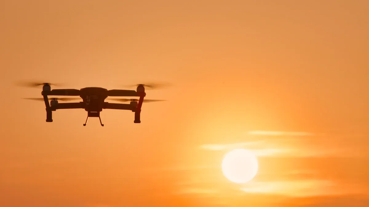
The top thermal imaging drones for 2025 are the DJI Mavic 3T, DJI Matrice 4T, Autel EVO Max 4T, Teledyne FLIR SIRAS, and Autel EVO II Dual 640T Enterprise. These drones are popular because they have advanced thermal imaging sensors. They can also fly for a long time. They follow new rules very well. Many industries use a thermal imaging drone for search and rescue. They also use them for checking buildings and for farming. The thermal imaging drone market is growing fast. This shows how important these drones are for work.
Key Takeaways
The best thermal imaging drones in 2025 have clear cameras, fly for a long time, and have smart tools that help with rescue, checking things, and farming jobs.
NDAA compliance is needed for safety and for government jobs, so buyers should see if drones follow these rules before buying.
Advanced thermal sensors can find small heat changes, so drones can find people, spot fires, and check machines.
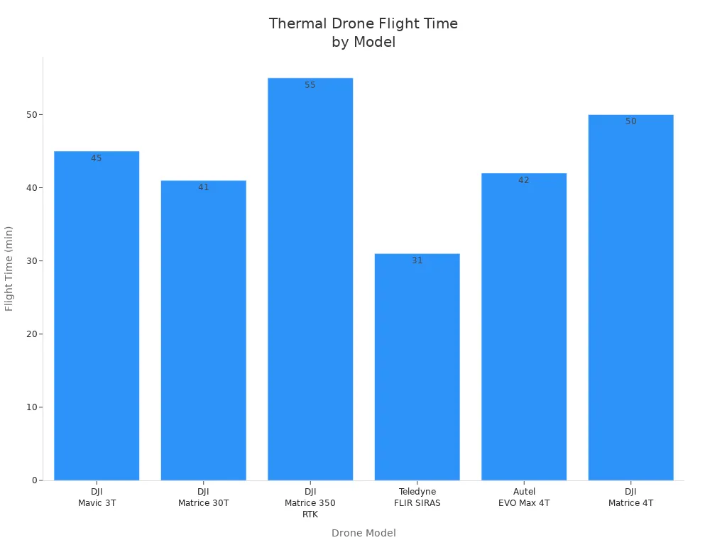
Flight time is between 30 and 55 minutes, so drones can look at big areas without changing batteries a lot.
Smart software and AI help drones move better, study data, and give alerts right away, so teams can work faster and safer.
Best Thermal Imaging Drones 2025
Top Models Overview
Experts say some thermal drones are the best for 2025. These drones have great sensors and can fly for a long time. They are good for many types of jobs. The table below lists the top thermal drones and what makes them special:
Drone Model | Key Features & Expert Notes |
|---|---|
DJI Matrice 30T | Good for search and rescue and security; has two thermal sensors; uses AI to track; flies for a long time; can change parts easily |
DJI Matrice 350 RTK | Used by professionals; cameras can be removed; has three gimbals; works at night and with heat; uses two batteries |
DJI Mavic 3T | Can fold up; zooms in; has two regular cameras and one thermal camera; flies for a long time; can swap out parts |
Autel EVO Max 4T | Made for businesses; has many sensors; thermal camera is 640×512@30fps; flies for 42 minutes; can go 20 km; uses AI to track |
Autel EVO II Dual 640T V3 | Can fold; has two cameras (one is 8K and one is thermal 640×512@30fps); can show both pictures at once; flies for 38 minutes; goes 15 km |
These drones take clear thermal and regular pictures. They fly steady and have smart features. People use them for rescue, checking things, and work in factories. The best drones have to meet some rules:
It must measure temperature very well.
It needs a gimbal to keep pictures clear.
It should fly for 30 to 50 minutes, and some can fly up to 4 hours.
It must be tough, handle wind, and have an IP55 rating.
Some drones like the DJI Matrice 30T and Autel EVO Max 4T can change parts and get new software. This helps them work for new jobs.
Compliance and Regulations
Following rules is very important for people buying thermal drones in 2025. Many groups want NDAA-compliant drones to follow government rules. NDAA compliance means the drone does not use banned foreign parts. This keeps data safe and lets people use them for government work. Companies have changed how they make drones to follow these rules.
The chart below shows the top NDAA-compliant thermal drones:
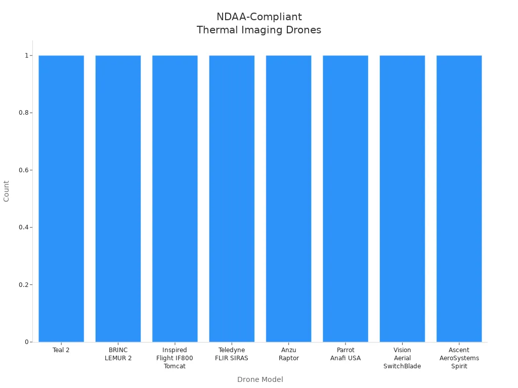
Drones like the Teledyne FLIR SIRAS, BRINC LEMUR 2, and Inspired Flight IF800 Tomcat follow these rules. People trust these drones for important jobs like keeping places safe and helping in emergencies. NDAA compliance also helps avoid bans and makes sure drones get support for a long time. Buyers should always check if a drone is compliant before using it for important work.
Thermal Drones: Key Features
Camera and Sensor Specs
Thermal drones in 2025 use advanced cameras and sensors. The most important part is the thermal camera. Most top drones have a thermal imager with 640 x 512 pixels or more. This high resolution helps the camera show clear thermal images. It works well even when it is hard to see. The table below shows what top thermal drones usually have:
Specification | Typical Values / Examples (2025) |
|---|---|
Thermal Camera Resolution | 640 x 512 pixels or higher |
Thermal Imager Type | Uncooled VOx microbolometers |
Temperature Measurement Range | -20°C to 550°C |
Visual Camera Resolution | 12MP to 50MP CMOS sensors |
Obstacle Avoidance | Omnidirectional or 720° systems |
Operating Temperature Range | -20°C to 50°C |
Zoom Capabilities | Up to 16x thermal, 32x visual |
Weather Resistance | IP55 rating |
Payload Flexibility | Swappable sensors or multiple cameras |
DJI and Autel make drones with sensors that find tiny temperature changes. These sensors can notice changes as small as 20 millikelvin. This helps the camera spot small differences. It is very important for rescue work or checking machines. Infrared thermal imaging drones now use these sensors with AI. This makes them better for hard jobs.
Flight Time and Range
Flight time and range are very important for thermal drones. Most top drones in 2025 can fly for 25 to 50 minutes. This lets people check big areas without changing batteries a lot. The chart below shows how long top drones can fly:
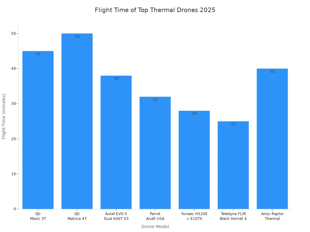
Some drones, like the DJI Matrice 4T, can fly for 50 minutes. They also have laser rangefinders to measure distance. Good GNSS support, like GPS and GLONASS, helps the drone know where it is. These things help thermal drones work well in tough places.
Software and Integration
Software makes thermal drones even better. Top platforms like DroneDeploy, Pix4D, and DJI Terra help plan flights and watch the drone in real time. They also help look at the data. The table below lists some main software choices:
Software Platform | Key Features Relevant to Thermal Imaging Drones | Industries Served |
|---|---|---|
DroneDesk | Flight planning, compliance reporting, DJI integration | Construction, inspection, surveying |
DroneDeploy | Automated flight planning, 3D modeling, data analysis | Construction, agriculture, mining, energy |
Pix4D | Thermal analysis, quality control | Construction, agriculture, public safety |
DJI Terra | 2D/3D model reconstruction, AI optimization | Surveying, emergency services, agriculture |
Agisoft Metashape | 3D models, georeferencing | Surveying, mapping, 3D modeling |
These programs let users see thermograms and change settings. They can also make reports. Alerts and live video help people act fast if temperatures change. Connecting with GIS and cloud services keeps drone data safe and easy to get. High-resolution thermal imaging and smart software make these drones very useful for building, farming, and safety jobs.
Leading Thermal Imaging Drone Models
DJI Mavic 3T
The DJI Mavic 3T is small and easy to use. Professionals like it because it is flexible. It has two cameras and can fly for a long time. Some important features are:
The thermal sensor is 640 x 512 and works at 30 Hz. This helps find temperatures very well.
There is a 48 MP wide camera and a 12 MP telephoto lens. The zoom goes up to 56×.
You can see thermal and regular images at the same time. The split-screen zoom helps with this.
The drone can fly for up to 45 minutes. It can send video from 10 km away.
It has sensors all around to avoid hitting things. DJI’s Advanced Pilot Assistance System (APAS) powers these sensors.
The drone has tools to check temperatures and mark problems right away.
It can measure temperatures in one spot or in an area. It gives alerts if it gets too hot. You can pick color palettes and isotherms.
It works with DJI Thermal Analysis Tool 3.0 for better image checks.
The controller is bright, so you can see it outside.
The Mavic 3T is great for search and rescue. It also helps with checking buildings and fighting fires. The split-screen zoom and good thermal accuracy help teams find problems fast. They can spot hot spots, broken parts, or missing people safely.
DJI Matrice 4T
Feature | DJI Matrice 4T Details |
|---|---|
Payload | Has wide, telephoto, and thermal cameras |
Thermal Imaging | High-resolution (640×512 and 1280×1024), radiometric, and near-infrared for night work |
Visual Camera | 48 MP wide camera |
Laser Range Finder | Measures up to 1.8 km |
Flight Time | Flies up to 50 minutes |
Weather Resistance | Strong, quick to set up, works in all weather |
Ideal Use Cases | Used for emergencies, firefighting, police, disasters, buildings, and animals |
The Matrice 4T gives live thermal images and finds heat in fog or dark. Its laser rangefinder and starlight vision help at night. Teams use it to find fire hot spots and watch at night. It is also good for helping during disasters.
Autel EVO Max 4T
The Autel EVO Max 4T is made for big jobs. Its FusionLight Camera has a 640×512 thermal camera. The lens is 9.1mm and can zoom in 16 times. The drone finds temperatures from -4°F to 1022°F. It does this very well. Operators get:
A 48 MP zoom camera and a 50 MP wide camera for clear pictures.
8K HD video and a laser rangefinder to measure distance.
SLAM navigation helps when GPS does not work.
It avoids things in all directions and has batteries you can change fast.
It can fly for up to 42 minutes.
The EVO Max 4T is good for safety, rescue, and checking factories. Teams use its thermal camera to find people in the dark. It also finds broken parts and checks disaster areas. AI helps it find and follow things in hard places.
Teledyne FLIR SIRAS
The Teledyne FLIR SIRAS is special for people who need safe and flexible drones. It has a 16 MP camera that can zoom up to 128 times. It also has a 640×512 thermal camera. FLIR MSX® technology puts visible lines on thermal images. This makes pictures clearer and easier to understand. SIRAS saves all data on SD cards. It does not use Wi-Fi or the internet, so data stays safe. There is no geo-fencing, so pilots can fly anywhere. You can swap out parts fast. It works with FLIR software for different jobs.
SIRAS is best for safety, fire, and factory checks. It is tough, flies for 31 minutes, and has an IP54 rating. It works well in bad weather. The drone keeps data private and safe, which is important for many users.
Other Notable Models
Some other thermal drones are good for special jobs and rules:
BRINC LEMUR 2: Made in America, follows NDAA rules, used for police and rescue.
Inspired Flight IF800 Tomcat: NDAA-compliant, can change parts, used for factories and government.
Autel EVO II Dual 640T Enterprise: Good price and works well, has a 640×512 thermal camera and 8K camera, used for checks and emergencies.
DJI Zenmuse H20T: Has strong zoom and many sensors, good for far-away checks and detailed thermal images.
Real-World Applications
Thermal drones help many jobs. Teams use them for:
Search and rescue: Finding lost people in forests, disasters, or at night.
Firefighting: Finding hidden hot spots, watching fires, and keeping crews safe.
Law enforcement: Watching crowds, tracking suspects, and doing surveillance.
Agriculture: Checking crops, finding water problems, and watching animals.
Infrastructure inspection: Finding broken parts, leaks, and insulation issues.
Wildlife monitoring: Tracking animals at night and stopping poachers.
These drones make work safer and faster. They help people reach dangerous or hard places. Their smart thermal cameras and AI help teams make quick, smart choices when it matters most.
Thermal Imaging Drone Comparison
Specs and Features Table
Picking the best drone means knowing how each one works in real life. The table below shows top thermal imaging drones. It compares their cameras, flight time, range, compliance, and special features. This makes it easier for people to see which drone is right for their job.
Drone Model | Camera Specifications | Flight Time | Max Range | Compliance | Unique Features |
|---|---|---|---|---|---|
DJI Matrice 30T | 48MP zoom, 12MP wide, 640×512 thermal camera, laser rangefinder | 41 min | 15 km | NDAA (partial) | Swappable payloads, AI tracking |
DJI Matrice 300 RTK + H20T | H20T: 20MP zoom, 12MP wide, 640×512 thermal camera, laser rangefinder | 55 min | 15 km | NDAA (partial) | Triple gimbal, night vision |
DJI Mavic 3T | 48MP wide, 12MP telephoto, 640×512 thermal camera | 45 min | 15 km | Not NDAA | Foldable, split-screen thermal/visual |
Autel EVO Max 4T | 50MP wide, 48MP zoom, 640×512 thermal camera, laser rangefinder | 42 min | 20 km | Not NDAA | SLAM navigation, AI object tracking |
Teledyne FLIR SIRAS | 16MP visual, 640×512 thermal camera, FLIR MSX overlay | 31 min | 5 km | NDAA | Data privacy, no geo-fencing |
21MP wide, 320×256 thermal camera, 4K video | 32 min | 4 km | NDAA | Lightweight, rapid deployment |
Note: NDAA compliance means the drone follows U.S. government rules for safety and parts.
The chart below shows how far and how long these drones can fly:
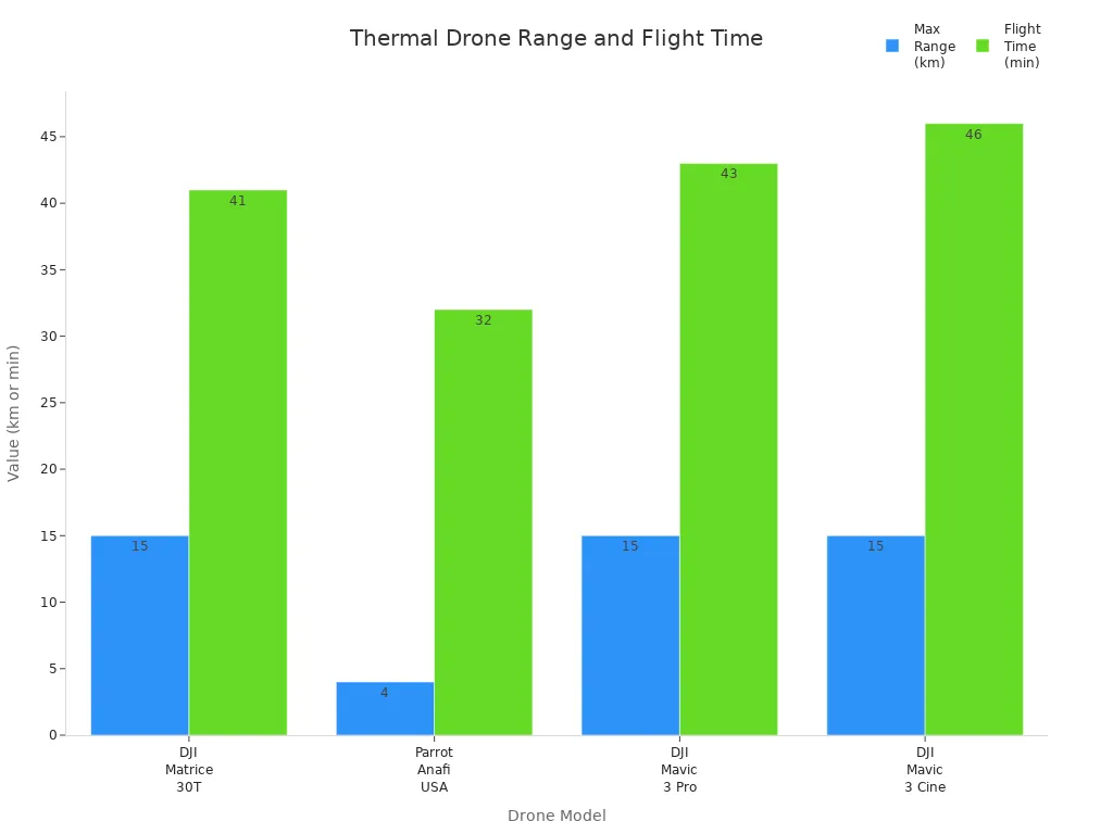
A good thermal camera lets teams find heat changes fast. Drones like the DJI Matrice 300 RTK and Autel EVO Max 4T can fly for a long time and have strong sensors. The Teledyne FLIR SIRAS is special because it keeps data safe and meets NDAA rules. Each drone has something different to help with rescue, checking things, or emergencies.
Choosing the Right Thermal Imaging Drone
Industrial Inspections
Industrial inspections need drones that are tough and last long. These drones must have high-resolution thermal sensors. Operators pick drones like the Skydio X10, DJI Matrice 350 RTK, and Autel EVO Max 4T. These models are known for being reliable and having smart features. They use AI navigation and can avoid obstacles. Their parts can be changed for different jobs. These drones check important places like power plants and building sites. The table below shows how top drones compare for these jobs:
Drone Model | Thermal Sensor Resolution | Flight Time (min) | Key Features & Advantages | Industrial Inspection Applications |
|---|---|---|---|---|
Skydio X10 | FLIR Boson+ 640×512 | 40 | Autonomous flight, AI navigation, modular payload, rugged design | Critical infrastructure, emergency response, confined spaces |
DJI Matrice 350 RTK | 640×512 or better | 55 | RTK positioning, multi-sensor payload, obstacle avoidance, intelligent flight modes | Large-scale infrastructure, energy, construction, public safety |
Autel EVO Max 4T | 640×512 thermal camera | 42 | 8K visual camera, 10x zoom, laser rangefinder, 720° obstacle detection, autonomous navigation | Law enforcement, firefighting, industrial inspections |
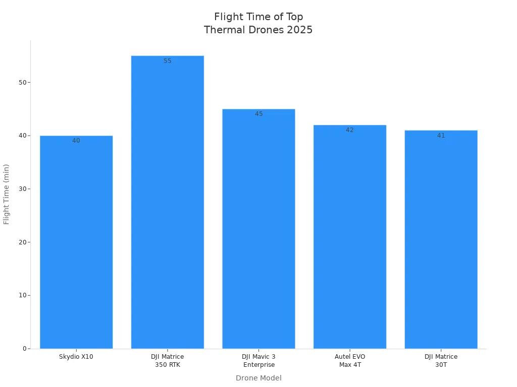
Drones like the DJI Matrice 4T and Autel EVO Max 4T are strong and smart. Their AI zoom and clear thermal images help a lot. These features make them great for hard jobs in tough places.
Search and Rescue
Search and rescue teams use drones with strong thermal cameras. These drones fly for a long time and send live video. This helps teams find missing people in forests or at night. The best drones have high-resolution thermal sensors and hybrid zoom. They also have more than one camera. The table below lists important features:
Feature | Description |
|---|---|
Thermal Camera Resolution | 640×512 px or higher for detailed heat detection |
Zoom Capabilities | Hybrid zoom up to 200x for precise identification |
Flight Time | Up to 55 minutes for large area coverage |
Weather Resistance | IP54 to IP55 for harsh conditions |
Portability | Lightweight for rapid deployment |
Multi-Sensor Payloads | Thermal and visual cameras for situational awareness |
Obstacle Avoidance | Advanced sensors for safe navigation |
Real-Time Data Streaming | Live video and telemetry for immediate coordination |
Long flights help teams search big areas.
Live video lets teams act fast.
Hybrid zoom helps spot dangers or people.
Obstacle avoidance keeps the drone safe.
Laser rangefinders and AI make work easier.
The Anzu Robotics Raptor T is a good example. It has a 640×512 thermal camera and 56x hybrid zoom. Teams can use these drones quickly and stream live video. This helps save lives during rescue missions.
Firefighting and Emergency
Firefighting and emergency teams need drones that are strong and last long. The DJI Matrice 300 RTK with Zenmuse H20T is a top choice. Its 640×512 sensor finds heat changes and hot spots. The drone can fly for 55 minutes and go 15 km. It works well in bad weather and strong wind because of its IP54 rating.
New drone control systems make flying safer and faster. These upgrades help the drone respond better and move more smoothly. Firefighting teams get safer and quicker help from the air.
Environmental Monitoring
Thermal drones help check the environment. They find heat changes to track animals and spot pollution. Drones like the DJI Mavic 3T, DJI Matrice 30T, and Autel EVO Max 4T are good for this. They have strong thermal sensors and can fly in tough places.
The DJI Matrice 300 RTK stands out with its 55-minute flight time. It can carry many types of cameras. This makes it good for long missions and checking big areas. The Autel EVO Max 4T has hybrid sensors and can follow moving things. These drones help people collect good data for research and protecting nature.
Tip: When picking a drone, think about weather, ground type, and what you need to do. Features like dual cameras, RTK, and AI help make every mission better.
Drone Model | Thermal Sensor | Flight Time | Best Use Cases |
|---|---|---|---|
DJI Mavic 3T | 640×512 px | Firefighting, inspections, rescue | |
Autel EVO Max 4T | 640×512 px | 42 min | Law enforcement, telecom, inspections |
Parrot Anafi USA | 320×256 px | 32 min | Urban surveillance, field operations |
Many experts pick the DJI Mavic 3T because it flies a long time. Its sensor shows clear thermal images. The Autel EVO Max 4T is good at finding things with AI. It can also avoid obstacles well. The Parrot Anafi USA is small and easy to carry. You can use it fast when needed. People should make sure drones follow NDAA rules. They also need to check local laws and keep data safe.
For the latest advice, ask the FAA, Teledyne FLIR, FlyEye.io, or TeamComplete.com.
FAQ
What industries use thermal imaging drones the most?
Many jobs use thermal imaging drones. Firefighters use them to find hot spots. Police use them to watch crowds or find people. Rescue teams use them to search for missing people. Inspectors check buildings and power lines with these drones. Farmers use them to watch over crops. Wildlife experts use them to track animals. These drones help people finish work faster and stay safe.
Are thermal imaging drones legal to use in the United States?
Yes, you can use thermal imaging drones in the United States. You must follow FAA rules when flying. Some jobs need special waivers from the FAA. NDAA compliance is needed for some government work. Always check your local laws before you fly a drone.
How accurate are thermal cameras on drones?
Thermal cameras on drones can spot tiny temperature changes. Some can notice changes as small as 0.02°C. Expensive models give clear pictures and exact numbers. This helps teams find problems fast during checks, rescues, or fires.
What is NDAA compliance, and why does it matter?
NDAA compliance means the drone uses only approved parts and software. The U.S. government wants this for safety reasons. NDAA-compliant drones keep important data safe. They can also be used for government jobs.
Can thermal drones fly in bad weather?
Most top thermal drones can handle rain, wind, and dust. They have weather ratings like IP54 or IP55. But very bad weather can still be dangerous for flying. Always read the drone’s manual before flying in tough weather.
See Also
The Importance Of Thermal Imaging Cameras In 2025
Using Thermal Imaging Cameras For Search And Rescue Missions
Best AI Video Devices For Vehicles Reviewed In 2025
Vanadium Oxide Thermal Cameras Designed For Rescue Operations